Pages

Wednesday, April 25, 2012

Kangaroo Island Adventure


I would like to apologies upfront but this is quite a long one, so get a cuppa first or if you just want to look at the photographs; then go here.

Kangaroo Island is such a special place that to try and write about our trip in just a few paragraphs would not do it justice and within my heart this has to be one of the most beautiful places I have visited. The step back in time which one takes when arriving is an integral part of the island’s character and something that needs to be enjoyed and celebrated.

Click for a larger view
With the Australia Day long weekend the decision was made to undertake a visit to Kangaroo Island which is Australia's third-largest island after Tasmania and Melville Island. It is 150km long and 57km at its widest. Kangaroo Island is rich in history. In 1802, British explorer, Matthew Flinders landed near Kangaroo Head on Dudley Peninsula. French explorer, Nicolas Baudin, followed soon after and mapped most of the island. Kangaroo Island (KI) became Australia's first free settlement, with sealers, escaped convicts and runaway sailors calling the island home.

Management at work only made the decision to give everyone a long weekend rather late in the month as the Thursday was the public holiday which then meant that the Friday off as well; this then made it worthwhile to so sightseeing. Finding accommodation so late in the month was the easiest part but unfortunately only a mid-morning ferry journey across the Backstairs Passage could be booked and an early morning crossing on the Sunday. Nevertheless it gave us two and half days on the island and when looking around at what we should visit one had the impression that it is more than enough time.

Click for a larger view
Kangaroo Island is about 7 times the size of Singapore and for those of us that have been there it seemed like a doddle considering one would not have to deal with the traffic and relentless taxis which keep Singapore moving. How wrong that turned out to be.

We set off nice and easy on Thursday morning and being a Public Holiday the roads were relatively quiet and we got down to Cape Jarvis without a hitch. The weather did not look all that bad either but by the time we got to the ferry port there was quite a gale going through the Backstairs Passage to the extent that the ferries were running 30 minutes late. Quite a lot considering that the sailing time is only takes 30 minutes. Anyway we checked in and they confirmed that the ferries are running. It was quite a trip across and hats off to the captain who did a brilliant job steering the ferry through the rough seas where at times the horizon disappeared completely as the ferry went through the trough. Arriving at Penneshaw the weather started to change and with the sun starting to come out we headed across the island to Stakes Bay where we were staying for the 3 nights.

It was quite a surprise to find that the speed limit on the island is 110kph on the tarred roads as much of South Australia is 100kph. Not that 10kph means much but when one is used to doing 120kph in other countries it does seem like a crawl. That is a discussion for another time.

We arrived at Waves and Wildlife early-afternoon and after getting ourselves checked in; which entailed reading the sign on the office door, going to the unit and letting yourself in and unpacking. For the whole time that we were there we never saw anybody in the office or even had to deal with them. I can just imagine doing that in some of the other countries we have been to.

Click for a larger view
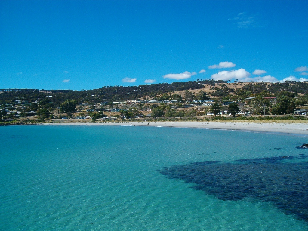
Anyway, the sun was shining so we went to start having a look around. Now Waves and Wildlife is at Stokes Bay and it must have the coolest entrance to any beach anywhere in the world. Arriving at the car park you’re assaulted by a shoreline littered with boulders with barely a grain of sand in sight. Then you notice a small, unassuming sign suggesting a beach exists somewhere near the rocky headland to the right.  You follow it to a similar sign which directs you to a small opening in the rocks – where there might be a grizzly bear. After a short passage through a tiny tunnel there it is – the beach and it is stunning.
Maybe it’s the sheltered rock pool or the dazzling white sand or the rugged coastline off in the distance, but there’s something truly spectacular about Stokes Bay.

Click for a larger view
Near the beach is The Rockpool Café and is most definitely recommended for a light meal. Unfortunately they are only open until 4/4:30 and then after that one is rather limited for any restaurants in the area as there are none. Supposedly Stokes Bar and Grill is at Stokes Bay and the best we could find was a roadside sign pointing towards the place but that was headed towards a heap of trees and a farm house without any signs or indication that it could be a place to eat. Anyway they do not have dinner serving and as we were out all day it did not really matter that much. Something that we have also not quite got used to in Australia is the complete lack of eating places around holiday spots; other than the hotels and pubs which all provide meals of some sorts.

Click for a larger view
With a full belly we headed out west to explore the beaches and sights along the north coast. The first place we came across was Snellings Beach which is at the mouth of the Middle River and from Constitution Hill one gets a beautiful view back over the bay.

Next on the coast was another of Kangaroo Island's spectacular beaches, Western River Cove is a quiet beach, far from the maddening crowds. The road follows the Western River through the valley and at the cove it flows into the sea. The hidden sandy cove also has some stunning geological formations exposing the granitic nature of KI. With a bit of a walk around it is quite evident that this picturesque area is ideal for swimming, rock and surf-fishing.

Click for a larger view
With the sun heading towards the horizon it was time to head on home and with most of the roads being gravel (quite loose on a number of stretches) and with abundant wildlife I did not want to drive in the dark.

When we got back to the chalet the advertised promise was kept and we had kangaroos grazing right in front of us. Being South African we came prepared for having the nightly barbie (braai) so having lit the gas fire it was simply fantastic to be sitting outside on the deck watching the roos while having a glass of wine and turning the meat until perfect.

Click for a larger view
A glorious first day had come to an end and one went to sleep thinking about how lucky one is to have such stunning scenery around and to be able to experience it.

The next day we woke to cloudy skies and after a couple of cups of coffee and brekky we headed off to the Flinders Chase National Park. It was an hour’s journey along the tar road and within that hour we only saw two other cars. That is one of the things about KI which adds to its character is that you can travel for an hour and be the only car on the road.

Since the creation of the national park in November 1919, Flinders Chase has become a sanctuary for endangered species, some of them introduced from the mainland in the 1920s and 1930s. During the 1940s, 23 additional species were introduced, including Koalas (1923) and Platypus (1928).

It is a sanctuary for endangered species and home to a few geological phenomena.

Click for a larger view
Remarkable rocks are one of the best known icons of Kangaroo Island. They are a collection of enormous eroded granite boulders sitting atop a giant dome of lava coughed up about 500 million years ago, boulders were formed by the rain penetrating the upper layer of the rock, decomposing it into separate boulders. Since then the wind, sea spray and lichen have since carved the chunks into what look like monumental Henry Moore sculptures perched 200 feet above a crashing sea.

The red colour of Remarkable Rocks comes from a tiny living plant, called lichen in contrast to the renowned Ayers Rock which also has a red colour but that comes from the natural colour of the granite which forms this world famous icon of Australia.

At Admirals Arch, located at Cape du Couedic in the Flinders Chase National Park one can only be amazed by the forces of nature. The viewing platform and boardwalk around a cliff face leads you to this spectacular natural rock arch, sculpted by weathering and erosion from the sea over thousands of years.

Click for a larger view
The Arch is a remnant of the ancient cave that was broken by ocean waves and transformed into a natural bridge. Stalactites are still hanging off the top of the arch as the evidence of its unusual history. The arch presents a geological significance and designated as a geological monument.

On the rock platforms we saw the colony of New Zealand fur-seals which have made this home. These dark brown seals feed at sea but return to land to rest and breed. Breeding occurs in summer when males establish territorial areas encompassing a number of females. Fur-seal pups can often be seen playing near the rock pools beneath the arch.


Click for a larger view
Unfortunately the weather was not at its best as can been seen from the photographs and we then decided to give the rest of the park a skip and as mid-afternoon was fast approaching thought it best to head back home. Now having never been someone to take the direct route the scenic route was chosen which took us along the southern coast. We also then gave Kelly Hill caves a skip and will do those with another visit.


We stopped in at Vivonne, a government proclaimed township of originally sixteen allotments. However, all but four allotments were ultimately resumed by the Crown as reserve. 1963 an estate of 220 allotments was established along banks of the Harriet River. In 1979, after investigation of the effects of erosion on the dunal system at Vivonne Bay, every esplanade allotment was compulsorily acquired by the Crown and these allotments now constitute a reserve.

Click for a larger view
There is a general store located on the South Coast Road, which will cater for most needs. From here it was home and so a second day came to a close and we had seen some truly remarkable sights which will always be with us.

Day 3 was set aside for the seals at Seal Bay where there is a large colony of the Australian Sea Lion on the beach. This is one of the most popular tourist destinations on KI. In order to protect the colony, visitors are only allowed on the beach by paying to go on a guided tour.

The world population is estimated at around 14,700. Of these, 85 percent live in South Australia and the other 15 percent in Western Australia.

Click for a larger view
Seal Bay supports the third largest colony of Australian sea lions with a population of around 1,000 - around five percent of the world's total.

The Australian Sea lion was nearly hunted to extinction in the 19th century. We can count ourselves lucky that places like Seal Bay exist today.

Females undertake three day fishing expeditions and, while we were there we witnessed a family reunion, when mum returns to the beach to be greeted by an excited pup. Also a couple of the big daddies were trying to make their presence known. Just being able to stand on the beach and look at these amazing animals 25m away was worth the trip to KI. Also the sun had come out so we had some glorious photographic weather. In fact thankfully we had our hats as the sun was quite vicious.

Click for a larger view
From here we headed towards Kingscote the biggest town on KI. Originally established at Reeves Point on 27 July 1836, it is South Australia's first official European settlement.
It is home to shops, facilities and half of the Island’s population – a lively town that is often referred to as KI’s ‘commercial hub’. Personally I found Kingscote to be a bit of a disappointment, but then perhaps I was expecting too much and also being a Saturday afternoon not a lot was happening. So we had a bit of a walk around and after having seen the scenes over the beautiful Nepean Bay headed out towards Emu Bay.

Click for a larger view
Along the route one passes the Lavender Farm which was worth the stop; but not for the lavender products, but rather that which we saw above us when walking to the car. Here was this little fella catching his afternoon nap in the fork of a blue gum tree.

Emu Bay is a small town of 97 allotments with an even mix of permanent and holiday homes. The town has no shops or mains water supply. Emu Bay is known as a popular swimming beach, and is one of few on KI where vehicles are permitted.

Click for a larger view
A small jetty dates to 1918. Originally 109 metres long, it allowed ketches such as Karatta to tie up to load cargoes, while a nearby fresh water well serviced horses which pulled wagons down to the bay. Until the 1930s, grain, stock and merchandise were taken to and from KI from this jetty.

It was getting on towards late afternoon so we headed back to Waves & Wildlife along the north coast road. The road climbs to about 300m and we got these beautiful vistas over the island looking towards Kingscote and the Cygnet River Valley.

With the gas barbie going we were able to sit outside and enjoy the company of the grazing kangaroos as we thought back onto a day which had such a highlight of being amongst the seals.

Click for a larger view
Now before we head home I must tell you about Parndarna which was our nearest town about 20km from the chalets. Parndana was established after the Second World War to support the Soldier Settlement Scheme on KI. The name "Parndana" means "The Place of Little Gums". It is located in the centre of the island and is home to a population of around 150, however most of this population do not live in the town, they are sprawled within a few kilometres.

Parndana truly comes alive in November when the annual Speed Shears event is held. Shearers from Australia and overseas compete in one of the richest shearing events in the world.

Click for a larger view
With the dawn of day four we knew it was time to head back home. Waves and Wildlife where we based ourselves is a cluster of chalets set on 80 acres bordering one of KI’s most beautiful beaches, directly behind the cliffs of Stokes Bay beach with no roads in between. It boasts everything you imagine KI to be with glorious views over Investigator Strait from the front deck.

Much of the property remains natural bush land which is home to large mobs of the KI Kangaroo which graze around the cottages every evening and can be seen around grazing the property or resting in shade of the surrounding trees during the day and that is a wonderful memory that we will always have with us.

Click for a larger view
Being an early Sunday morning journey out to be on the 10:30 ferry meant the road was quiet and we had some of our last views of this beautiful island before reaching Penneshaw which is where the ferry port is located. Penneshaw, the second largest town on Kangaroo Island, has a population of around 300, and is located on the north eastern tip of the Dudley Peninsula, on the eastern end of the island.

The ferry journey across the Backstairs Passage was very different from the crossing to KI. In complete contrast we had a beautiful calm sea with some great views towards KI and also Cape Jervis. It was with real sadness that one left KI and if the cost of the ferry crossing was a lot more reasonable we would be there on a regular basis considering the Cape Jervis is only 60 minutes from home; by direct route that is. But the $348 return trip must make it one of the most expensive ferry crossings in the world and that makes KI very expensive to weekend on.

Click for a larger view
Thank you for allowing me to share this adventure with you and until the next visit be careful wherever you are.

The Barossa Valley


The Barossa Valley is probably of the best known Australian Wine Regions and when you mention wine territory and South Australia in the same sentence; it is Barossa that comes to the mind of most people. This is probably helped along by some of the big names, like Jacob’s Creek, Yalumba, and Peter Lehmann to but a few who all have wineries in the valley.


Click for a larger view
The Barossa Valley is an area adjacent to the North Para River and encompasses the towns of Nuriootpa, Tanunda, Rowland Flat and Lyndoch.

Due to me having to do the driving not that much wine tasting was undertaken and it could almost be thought of as a recce trip so scout the area before a short long weekend is taken and spent in the valley.

Just outside Gumeracha on the Torrens Valley Road one will find the Big Rocking Horse and a wonderful little toy factory. This place is a must stopover for young and old alike. We spent a wonderful hour wandering around the factory playing with the toys that they have on display, some old and some new. Be warned – take your credit card with you.

A stop at Jacob’s Creek Winery is a must. Within the visitors centre they take you through the history of the winery and then you have the opportunity to do some tasting and purchasing. Within the grounds of the winery is also a majestic Blue Gum Tree said to be over 300 years old.
Click for a larger view

From the top of Menglers Hill outside Tanunda you get the very spectacular panorama over the Barossa Valley.

We stopped over at Chateau Tanunda Estate in for a bit wine tasting and I can really recommend their wines and they have a brilliant cellar.

Click for a larger view
With everything there is to see and do the time passes by all too quickly and very soon we realised that it was time to head back home. We will most definitely be back for a longer visit at some time in the not too distant future.

Here you will find a few more photographs of this fleeting visit.

Murray Bridge


Everyone in South Australia talks about cruising on the River Murray be it in a houseboat or one of the old paddle steamers that tour along the river from various little places. Doing a bit research while Vanessa and Grant were here I found a paddle steamer (Captain Proud Paddle Boat Cruises) that uses Murray Bridge as a berthing spot. 

Click for a larger view
Having never done anything like this before it was with great excitement that we left home on that morning. Taking the drive down from Adelaide towards Victor Harbor we turned off at Mount Compass and headed towards Strathalbyn. Between Ashbourne and Strathalbyn the road climbs up to the crest of the Woodland Ranges and this gave us some great views of Lake Alexandrina.

A short drive later we were at Murray Bridge and found the berthing spot for Captain Proud. The hand written board at the entrance confirmed that the paddle steamer was running, but no steamer could be seen and the sign confirmed that the next trip was to be a in a short while. Quite a few cars parked around but no real sign of life at the quay side. 

Click for a larger view
We decided to go and find out if we were in the right place and whether the steamer was even running. No one could tell us and the best we got was from the waterside restaurant where one of the staff stated that she had not yet seen it today. Anyway tried to give them a call on the mobile, but to no avail and in the end we gave up, went to have some lunch and then drove back home taking a scenic route. I would recommend the Riverscape Restaurant & Café as they did us a great meal. 

Having been here now some 10 months it is something that still continues to amaze and which we have not yet quite got used to; nothing really happens as advertised and schedules are not really stuck to. One has to simply see them as an indication of what potentially maybe could happen if all goes according to the plan which has not yet been fully developed and thought through. It is a bit like the TV guide; it is just a guide and there is no certainty that the program advertised will start and finish at the time advertised or that the program will even be shown. Trying to record TV programs is like trying to guess the winning lottery numbers and the only way to do it, is to start recording 30 minutes prior to the advertised time and for at least 60 minutes longer than the duration specified and that way your window of opportunity will be large enough so that if the program is shown you should be able to find out who did it.

Click for a larger view
So perhaps in another few years we will also say; “No worries mate. Just do it next time you’re around”

After the disappointment of no steamboat ride we had to do something else to make the day memorable because at this stage it was turning out to be darn disappointing. Taking a look at the map we then decided to follow the River Murray down to Lake Alexandrina. Now the countryside through here is as flat as a pancake and one can see for kilometres, there is just nothing higher that a tree to see which makes the statement all a bit pointless actually. Anyway we followed Princes Highway (road to Melbourne) to Tailem Bend and then took the ferry across the River Murray.

Tailem Bend Ferry
Quite an interesting journey then ensued down to Wellington where the river flood plain is quite wide and one could see that in years gone by the river must have been something to behold. From Wellington we then cut back west towards Mulgundawa and onto Milang on the shores of Lake Alexandrina. All along this section one gets great glimpses of the lake.

Lake Alexandrina is not a lake in the true sense of the word as it is part of the River Murray Estuary, it is only during times of high flow that the lake does drain into the ocean (into Encounter bay) at a Murray Mouth near Goolwa. Normally this channel is blocked by a sand bank. The lake was originally subjected to tidal and storm inflows of seawater. But through modern times the lake is now maintained as fresh water by a series of barrages across the islands near the Murray Mouth. Ecologically the state of the lake is on a downward spiral due to the reduced amount of water flowing into the lake from the increased water take upstream in New South Wales and Victoria, which over the past number of years has increased the salinity and is starting to have an effect on the agricultural areas of South Australia which depend on the river as a water source as well as towns in South Australia including Adelaide which depends on the river during certain times of the year.
Click for a larger view

I am going off topic here. Even at ground level the change in the colour of the water is most noticeable and when seen for the first time I just put it down to muddy waters but now actually understand that the colouring is being driven by this eco-system within the river and is to a certain extent man-made.

From Milang we headed back home to Mount Compass and then onto Seaford. It turned out to be quite a long journey for the day and quite boring in parts. Having not done the steamboat ride was a big disappointment to us all and perhaps we will get back next summer to do it.

Much like the other blogs; if you would like to see some photographs then have a look here.

Victor Harbor in a Day

Victor Harbor is a seaside town about 45 minutes south of us on the coast of the Fleurieu Peninsula. The economy is based various industries including fishing and agriculture. Due to the great variety of attractions and things to do it is a highly popular tourist destination.

Click for a larger view
An interesting little known fact: I have got the spelling right and have not suddenly switched to an American spell checker. Originally called Port Victoria, in 1921 the town’s name was changed to ‘Victor Harbor’ , which was originally blamed on some confusion around a near shipwreck with Port Victoria in the Yorke Peninsula. As children we learnt that harbour is normally spelt with a u yet many places in South Australia, such as Outer Harbor, are not spelt this way. This is due to some spelling errors made by an early Surveyor General of South Australia. Conversely Victor Harbour railway station is spelt with the u.

Click for a larger view
One of the main attractions is Granite Island which home to the Fairy Penguins (or little Blue Penguins) and access to the island is via the pedestrian walkway which is shared with one of the few remaining horse drawn trams.

The Cockle Train heritage railway also operates from Victor Harbour Station to Goolwa and this remains a trip which still needs to be undertaken. This winter possibly.

The views across Encounter Bay are stunning from Granite Island and one can see all the way across the bay to the mouth of the River Murray. Encounter Bay was named by Matthew Flinders in April 1802 after he encountered Nicolas Baudin near the Murray Mouth while surveying this unknown stretch of coastline.

Click for a larger view
The town has some beautiful beaches and with great leisure areas adjacent to the sand and surf.

The town centre has quite a historic feel about it and there are quite a few buildings dating back to the late 1890’s.

During the months of June to September, the Southern Right Whales come to the nearby waters to calve and to mate; and this has become quite a tourist attractions. The South Australian Whale Centre has a whale watch notice board which tells you where whales have been sighted; giving rise to a whole new hobby of whale chasing during the winter months.

Click for a larger view
If you would like to see some more photographs of this wonderful little coastal hamlet then please click here.

Seaford to Cape Jarvis


Sellicks Beach to Adelaide

Taking the B23 out of Seaford and heading south one will travel along through some of the most picturesque scenery of the Fleurieu Peninsula. Just after having made the climb up Sellicks hill there is a rather inconspicuous turn off sign posted as a photo opportunity. The road climbs rather steeply from the main road and from the top one gets a spectacular view across the Gulf of St Vincent taking your eye from Sellicks Beach in the foreground to Adelaide in the distance.

Myponga Reservoir
Carrying on along the road you will find Myponga Reservoir; which is one of the reservoirs supplying Adelaide with potable water. The dam wall is single concrete arch with a ski jump spillway. The reservoir has a capacity of 26,800 megalitres and was completed in 1962 after four years of construction. The wall has a length of 226m and maximum height of 49m.

After crossing the dam wall turn right at the T-junction and head towards Myponga Beach (a later visit required) and after following crossing all along the tops of the coastal hills one starts to descend into Carrickalinga which is a beautiful coastal hamlet with no shops. The town is close to emerging wine lands from the southern vale region and no doubt will grow over time.

Right next door is the town of Normanville on Yankalilla Bay. It is more established with a beautiful stretch of beach north and south. The beach is a popular spot for fisherman to launch their craft before spending a day a sea while the family enjoy the very safe bathing beach.


Normanville was established in 1850 by South Australia’s first dentist; Robert Norman. Due to the successful growing of wheat in the area, the town built a jetty for the ships transporting wheat around the coast; which today is used purely for recreational purposes as development of Adelaide meant it lost its importance.

Today it is wonderful little holiday resort popular with snorkelers, fisherman and the general holiday tourist.


Travelling along the coastal road one will encounter Lady’s Bay which with its pebble strewn foreshore and is the colloquial name given to a settlement of 21 shacks established about 50 years ago. It is also here that the Australian sank the HMAS Hobart at the end of its usable life to create a dive wreck off the coast.

The next turn off leads you to Wirrina Cove also to be done with the next trip. We did this journey in December at the height summer and that can be seen from the scenery which looks rather dry and dusty and it is. We will do this again during the winter months when the grasslands and wheat fields are green and I think the change will be amazing. Anyway I digress and on with the trip.
Leonards Mill

The next stop is at Second Valley and here you will find the Leonards Mill Hotel. They do a wonderful lunch and we have been twice now; once with the exploration of the coast and then when we came back from Kangaroo Island.

Finally we reached our destination of Cape Jervis located at the south western tip of Fleurieu Peninsula. The ferries use Cape Jervis as the mainland port for the crossing of Backstairs Passage to Penneshaw on Kangaroo Island.

Cape Jervis
Matthew Flinders named Cape Jervis after John Jervis, the British First Lord of the Admiralty in 1802.

The views across the Backstairs Passage towards Kangaroo Island are simply magnificent; particularly on a clear day when one can see across the 13km stretch of water and looking east over Investigator Strait.

If you would like to see some photographs of the trip down the Fleurieu Peninsula then have a look here.

Cleland Wildlife Park


Cleland Wildlife Park is a beautiful area nestled in the Lofty Ranges about 60 minutes from home. We have now visited the park twice; once in spring and then during December when my daughter (Vanessa) and her husband (Grant) came to visit.
Click for a larger view
Besides the Koalas they also have the three of the five kangaroo species within the park as well as two of thirty (some extinct) species of wallaby along with Wombats, Emus, Echidnas, a pack of Dingoes and a whole host of bird varieties.


Click for a larger view

A number of the animals are free to roam around the park and the visitor is encouraged to feed them and touch them. The animals are mostly ones that have been rescued and although not domesticated appear to have lost the fear of humans. The kangaroos in particular will come up to you and readily take food (which they sell at the entrance) from the open hand and then be kind enough allow you to give them a slight soft stroke.

Each visit that we have had has been unique and on each occasion we saw something new or the same animal but in a different circumstance which makes each experience different. No doubt we will be back again and again. I particular I would like to go and sit in one of the aviaries and just watch the birds going about their daily tasks.

Click for a larger view
With the Koalas being so unique and different to anything else that one has seen around the world they absolutely captivated me and it was instant love. They are simply adorable and considering how vulnerable they are it is great work that Cleland are doing in giving these a home. Most of the animals that they have are rescued and in particular from the many bush fires that occur annually around in Adelaide.

If you would like to see more photographs of the visit click here.

Wednesday, September 14, 2011

Three months already - almost


Time is absolutely flying past and our arrival almost three months ago is now just a distant memory and there has been quite a lot of water flowing under the proverbial bridge.

In the last update I promised a bit of information on the project. Rather than regurgitating what is already out there it is perhaps the easiest to just refer you to the following which gives you a flyover.

Almond tree in full bloom
The following is time lapsed video from two cameras which we have setup on the northern and southern abutments of the viaduct.

A good write up on the project can be found on our Client’s website page here

The pace of work is slowly starting to ramp up and over the next few months towards the year end it will be undergoing quite a change with work then progressing on all fronts and in all areas.

A month ago we went to the local Almond Blossom Festival which is held annually in August when the almond trees start to blossom. It is held in the picturesque little village of Willunga which is about a 30 minute drive from Seaford and well settled within the wine growing area.

Almond Festival
The festival takes place over three days with a big float parade on the Saturday morning (which we missed) and then a carnival on Saturday and Sunday. Generally some good family entertainment and quite interesting to see how the Aussies do it compared to other farm festivals that I have been at around the world. Nothing has yet beaten the Peruvian one in Huallamayo which went on for a whole week during which many litres of Pisco Sour was consumed.

I digress. The weather the past few weeks has been absolutely brilliant with horizon to horizon blue skies almost every day and all day. Spring is most definitely in the air and our garden is starting it’s transformation with the first rose blooms already open and the daffodils have gone. I think we just had a barmy weather bout which got nature all confused.

Willunga Main Street
Well we have almost settled in with only a few boxes left to be unpacked. Mainly all the junk which I continue to drag all over the world and then seriously contributed towards by my decision to build some decent book cases. The next time a mention building anything, will somebody please remind me that it takes time and that the timber faeries don’t do it. Anyway almost there and this weekend that should be done and then we can start to play tourist proper. Just in time for summer I think.

Victor Harbour Beach Boardwalk
It has not just been all work and no play. We have taken a day trip out; or should I say down, to Victor Harbour which is about an hour from us. Victor Harbour is steep in the whaling history of South Australia and is a real holiday town. We a great time wander about the ‘village’ and it will most definitely require numerous visits back. There is just too much to see in one day and the list currently contains (in no particular order);
  • ·       Visit to local brewery
  • ·         Train ride on the heritage line between Victor Harbour and Goolwa
  • ·         Horse Drawn tram ride across the causeway across to Granite island with a walk around to see the magical little penguins which inhabit the island.
  • ·         The Big Duck Boat Tour along rugged coastline.

Causeway to Granite Island
Hotel Victor Harbour Town Centre
We have seen our first herd of kangaroos and subsequently seen them quite close. The project cuts through a nature reserve and they are often seen when out on site and Karin has to be careful in the morning bringing me to work as they just suddenly decide to cross the road. Not much of an effort for them and the other morning a big red decided to cut across and it was 3 jumps and he was over the road and the fences on either side. Koalas, not yet and although one does see signs everywhere along the roads asking one to be careful; they being mainly active at night so we may have to go out on a more organised trip to see them in the wild.

This blog has a subscription feature so you can subscribe to it and it will then let you know when I have made any changes or added anything new. So do consider subscribing.


Clicking on the photograph should give you a larger view

Well that is all for now so take care and be safe.